Table of Contents
- Introduction
- Editor’s Choice
- Synthetic Aperture Radar Market Overview
- History of Synthetic Aperture Radar Technology
- Components of Synthetic Aperture Radars
- Specifications of Synthetic Aperture Radar Technology
- Cost of Synthetic Aperture Radar (SAR) Satellite Imagery
- Various Synthetic Aperture Radar Programs and Initiatives
- Regulations for Synthetic Aperture Radar
Introduction
Synthetic Aperture Radar (SAR) is a cutting-edge radar technology that produces high-resolution images by mimicking a large antenna through the movement of a radar platform, such as a satellite or aircraft.
It operates by emitting microwave pulses towards a target and measuring the return time of the reflected signals, using the Doppler effect to enhance image clarity.
SAR systems consist of essential components like the radar transmitter, receiver, antenna, and signal processor for reconstructing images.
By leveraging platform motion to create a large synthetic aperture, SAR enables detailed imaging and is applicable in fields such as Earth observation, military surveillance, and resource management.
Despite its ability to deliver high-resolution, all-weather aerial imaging, SAR requires complex data processing and accurate motion compensation.
Editor’s Choice
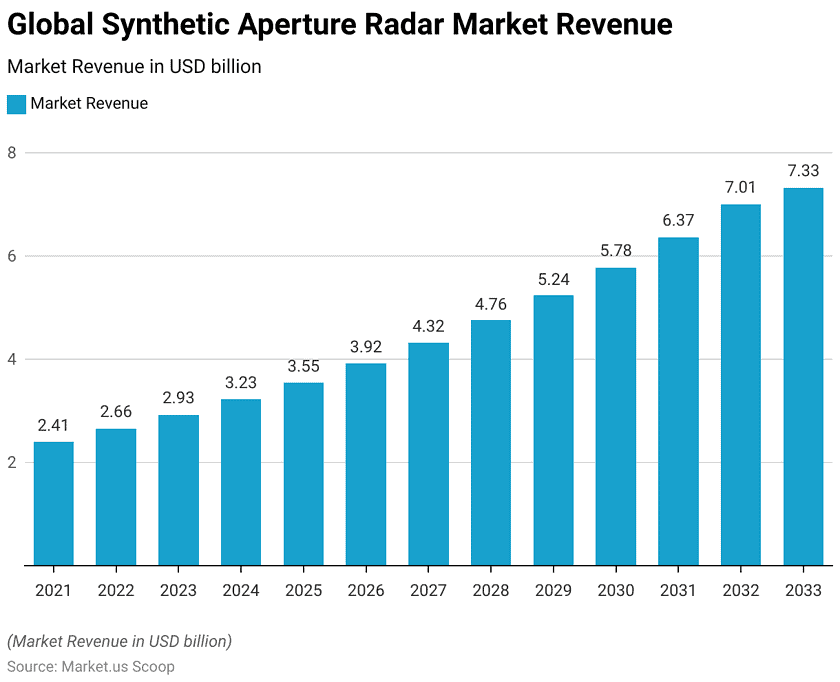
- The global synthetic aperture radar (SAR) market revenue reached USD 2.93 billion in 2023.
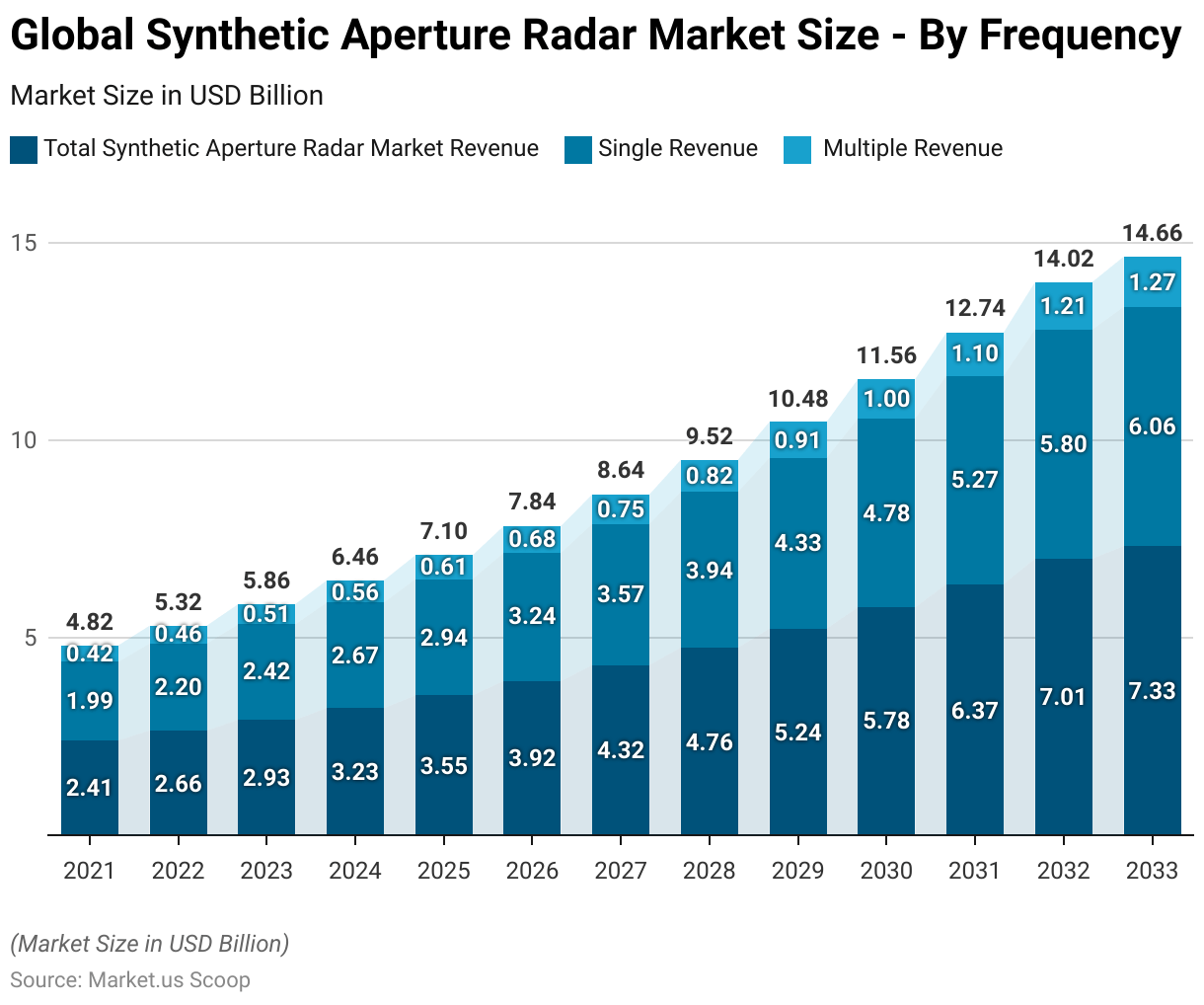
- By 2033, the global SAR market is forecasted to achieve USD 7.33 billion in total revenue. With single frequency contributing USD 6.06 billion and multiple frequency USD 1.27 billion.
- Synthetic Aperture Radar (SAR) technology, conceptualized in 1951 by Carl A. Wiley at Goodyear Aircraft Co., marked a significant innovation in radar systems by utilizing the Doppler effect to generate high-resolution images.
- The global Synthetic Aperture Radar (SAR) market is predominantly driven by multi-mode systems. Which commands a substantial 72.70% share of the market.
- The global Synthetic Aperture Radar (SAR) market is primarily divided between two major applications: commercial and defense. The defense sector holds a slight majority, with a market share of 53.70%.
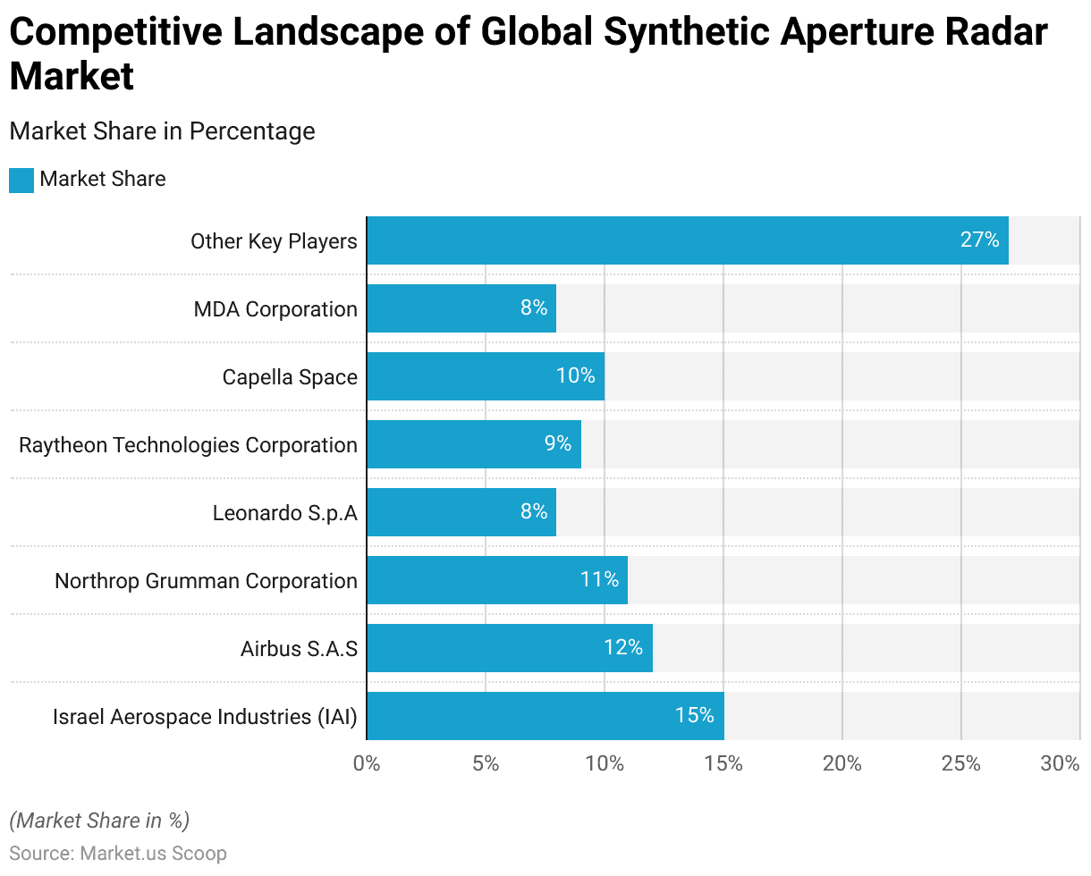
- The presence of several key players characterizes the global Synthetic Aperture Radar (SAR) market, each holding significant market shares. Israel Aerospace Industries (IAI) leads the market with a share of 15%.
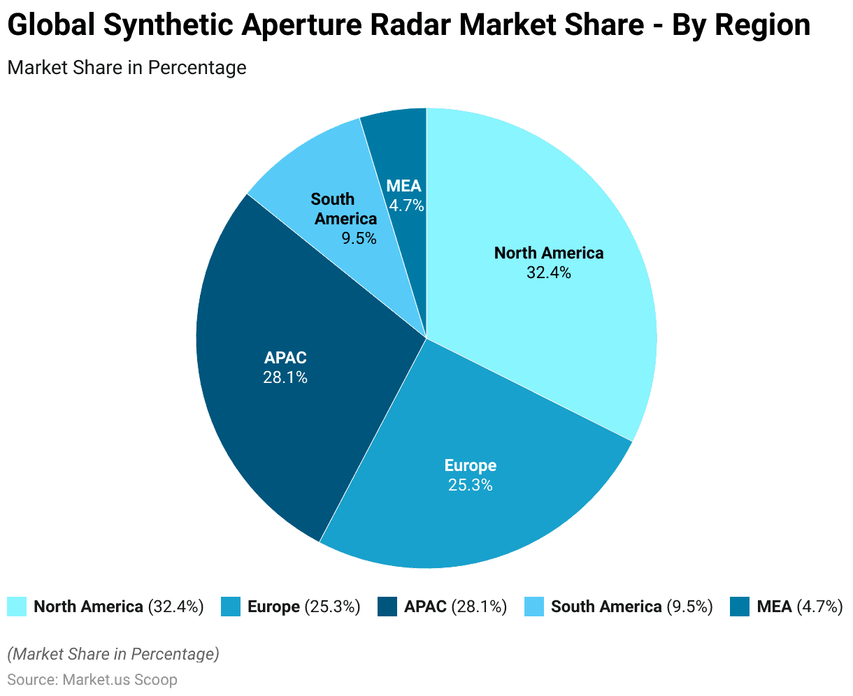
- The global Synthetic Aperture Radar (SAR) market is distributed across various regions, each contributing a significant share. North America holds the largest share at 32.4%.
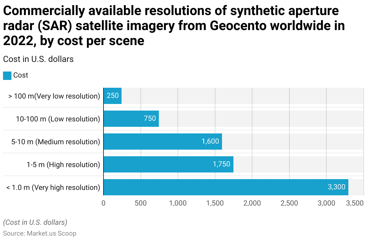
- In 2022, the cost of commercially available Synthetic Aperture Radar (SAR) satellite imagery from Geocento worldwide varied significantly based on the resolution of the images. Very high-resolution images, with resolutions of less than 1.0 meters, were priced at $3,300 per scene.
Synthetic Aperture Radar Market Overview
Global SAR Market Size
- The global Synthetic Aperture Radar (SAR) market has exhibited a consistent upward trajectory in revenue over recent years at a CAGR of 10.2%.
- In 2021, the market revenue stood at USD 2.41 billion and increased to USD 2.66 billion in 2022.
- By 2033, the global SAR market revenue is forecasted to attain USD 7.33 billion.
Global SAR Market Size – By Frequency
- The global Synthetic Aperture Radar (SAR) market, segmented by frequency, has shown steady growth in both single and multiple-frequency revenues.
- In 2021, the total market revenue was USD 2.41 billion, with single-frequency revenue contributing USD 1.99 billion and multiple-frequency revenue accounting for USD 0.42 billion. By 2033, the global SAR market is forecasted to achieve USD 7.33 billion in total revenue. With single frequency contributing USD 6.06 billion and multiple frequency USD 1.27 billion.
Competitive Landscape of Global Synthetic Aperture Radar Market
- The presence of several key players characterizes the global (SAR) market, each holding a significant market share.
- Israel Aerospace Industries (IAI) leads the market with a share of 15%. Followed by Airbus SAS with 12% and Northrop Grumman Corporation with 11%.
- Raytheon Technologies Corporation and Capella Space each hold 9% and 10% of the market, respectively.
- Leonardo S.p.A and MDA Corporation each command an 8% market share.
- The remaining 27% of the market is distributed among other key players.
Regional Analysis of the Global SAR Market
- The global Synthetic Aperture Radar (SAR) market is distributed across various regions, each contributing a significant share.
- North America holds the largest share at 32.4%, reflecting its strong presence in the SAR industry.
- The Asia-Pacific (APAC) region follows with 28.1%. Indicating rapid growth and increasing adoption of SAR technology.
- Europe accounts for 25.3% of the market, showcasing its substantial role in the sector.
- South America and the Middle East & Africa (MEA) have smaller shares, with 9.5% and 4.7% respectively.
History of Synthetic Aperture Radar Technology
- Synthetic Aperture Radar (SAR) technology, conceptualized in 1951 by Carl A. Wiley at Goodyear Aircraft Co., marked a significant innovation in radar systems by utilizing the Doppler effect to generate high-resolution images.
- Initial developments in the 1950s focused on military applications, driven by the need for all-weather, day-and-night reconnaissance capabilities.
- By 1957, the University of Michigan’s Project Wolverine successfully demonstrated airborne SAR. Achieving noteworthy advancements despite the analog processing limitations of the time.
- The 1978 launch of Seasat by NASA represented a pivotal moment. Introducing the first civilian spaceborne SAR and pioneering digital image processing techniques. This milestone catalyzed widespread civilian applications, ranging from environmental monitoring to disaster management.
Components of Synthetic Aperture Radars
- Synthetic Aperture Radar (SAR) systems are composed of several critical components that enable their high-resolution imaging capabilities.
- The primary components include the radar antenna, which is responsible for transmitting and receiving electromagnetic signals. These antennas can vary in size, with larger antennas providing higher-resolution images.
- The transmitter generates the radar pulses, typically using frequencies in the microwave range. Such as X-band (8-12 GHz), C-band (4-8 GHz), and L-band (1-2 GHz). The receiver captures the reflected signals from the target, which are then processed to construct images.
- Signal processing units are essential for managing the phase history and combining multiple radar echoes to form a synthetic aperture. Thus enhancing resolution beyond the limitations of physical antenna size.
- Other vital components include the data storage and processing systems. Which handle large volumes of data and apply algorithms for image reconstruction and analysis.
Specifications of Synthetic Aperture Radar Technology
- Synthetic Aperture Radar (SAR) is a sophisticated imaging technology that leverages the motion of a radar antenna over a target area to create high-resolution images.
- Key specifications of SAR include its velocity and aperture. For instance, NASA’s NISAR mission will utilize an L-band radar with a wavelength of 24 cm and an S-band radar with a wavelength of 10 cm.
- SAR systems, such as the Phased Array Type L-band Synthetic Aperture Radar (PALSAR). Can operate at altitudes around 600-700 km with inclinations near 98 degrees.
- These systems transmit microwave signals, which can penetrate clouds and rain, ensuring functionality in various weather conditions. SAR’s resolution is dictated by factors such as antenna diameter and transmitted pulse width. Achieving resolutions as fine as 5-7 meters along the track.
Cost of Synthetic Aperture Radar (SAR) Satellite Imagery
- In 2022, the cost of commercially available (SAR) satellite imagery from Geocento worldwide varied significantly based on the resolution of the images.
- Very high-resolution images, with resolutions of less than 1.0 meters, were priced at $3,300 per scene.
- High-resolution images, with resolutions ranging from 1 to 5 meters, cost $1,750 per scene.
- Medium-resolution images, with resolutions between 5 and 10 meters, were available for $1,600 per scene.
- Low-resolution images, with resolutions from 10 to 100 meters, were priced at $750 per scene.
- Finally, very low-resolution images, with resolutions greater than 100 meters, were the most affordable at $250 per scene.
Various Synthetic Aperture Radar Programs and Initiatives
- Leading organizations have developed Various (SAR) programs and initiatives to leverage the technology for diverse applications.
- NASA’s NISAR mission, in collaboration with ISRO, features L-band and S-band SAR instruments aimed at monitoring agricultural conditions forest biomass, and measuring ice sheet dynamics and natural hazards.
- The European Space Agency (ESA) operates the Sentinel-1 constellation. Which utilizes C-band SAR for environmental monitoring, maritime surveillance, and disaster response.
- Canada’s RADARSAT program, managed by the Canadian Space Agency (CSA), employs multi-mode C-band SAR for wide-area monitoring of sea ice. Surveillance of the marine environment, and disaster management.
- Additionally, the GeoSAR program is a joint initiative by NASA and commercial entities like Fugro EarthData. Utilizes P-band and X-band SAR for topographical mapping and forestry applications.
Regulations for Synthetic Aperture Radar
- The regulatory landscape for (SAR) systems is intricate, with varying standards across different countries. Reflecting both national security concerns and commercial interests.
- In the United States, the National Oceanic and Atmospheric Administration (NOAA) recently lifted numerous restrictions on commercial remote sensing licenses. Enabling higher-resolution SAR imagery benefits companies like Umbra. This move aims to bolster US competitiveness in the global market.
- The National Reconnaissance Office (NRO) is also formalizing programs to procure commercial SAR data, emphasizing long-term cost efficiency and operational capabilities.
- In Europe, regulations are more harmonized across member states due to the European Space Agency’s (ESA) oversight. Promoting the integration of SAR capabilities for both commercial and defense applications.
- In Asia, China and India are significant players; China’s Gaofen-7 satellite and the NASA-ISRO SAR (NISAR) project underscore a strategic push towards advanced earth observation capabilities.


