Table of Contents
- Introduction
- Editor’s Choice
- Synthetic Aperture Radar Market Overview
- History of Synthetic Aperture Radar Technology
- Components of Synthetic Aperture Radars
- Specifications of Synthetic Aperture Radar Technology Statistics
- Synthetic Aperture Radar Band Designations and Applications
- Cost of Synthetic Aperture Radar (SAR) Satellite Imagery
- Various Synthetic Aperture Radar Programs and Initiatives
- Regulations for Synthetic Aperture Radar
- Recent Developments
- Conclusion
- FAQs
Introduction
Synthetic Aperture Radar Statistics: Synthetic Aperture Radar (SAR) is a cutting-edge radar technology that produces high-resolution images by mimicking a large antenna through the movement of a radar platform, such as a satellite or aircraft.
It operates by emitting microwave pulses towards a target and measuring the return time of the reflected signals, using the Doppler effect to enhance image clarity.
Moreover, SAR systems consist of essential components like the radar transmitter, receiver, antenna, and signal processor for reconstructing images.
By leveraging platform motion to create a large synthetic aperture. SAR enables detailed imaging and is applicable in fields such as Earth observation, military surveillance, and resource management.
Despite its ability to deliver high-resolution, all-weather imaging, SAR requires complex data processing and accurate motion compensation.
Editor’s Choice
- The global synthetic aperture radar (SAR) market revenue reached USD 2.93 billion in 2023.
- By 2033, the global SAR market is forecasted to achieve USD 7.33 billion in total revenue. With single frequency contributing USD 6.06 billion and multiple frequency contributing USD 1.27 billion.
- Synthetic Aperture Radar (SAR) technology, conceptualized in 1951 by Carl A. Wiley at Goodyear Aircraft Co., marked a significant innovation in radar systems by utilizing the Doppler effect to generate high-resolution images.
- The global Synthetic Aperture Radar (SAR) market is predominantly driven by multi-mode systems, which command a 72.70% market share.
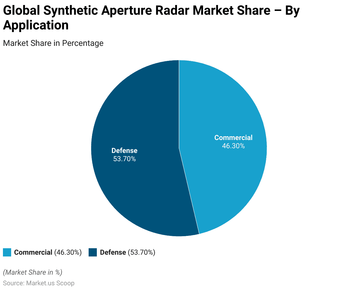
- The global Synthetic Aperture Radar (SAR) market is primarily divided between two major applications: commercial and defense. The defense sector holds a slight majority, with a market share of 53.70%.
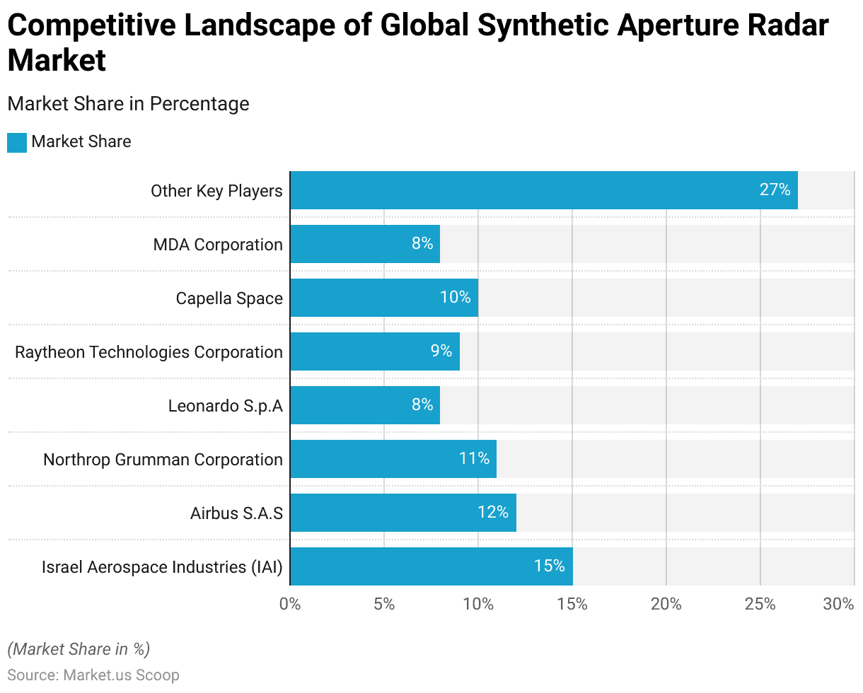
- However, Several key players characterize the global Synthetic Aperture Radar (SAR) market, each holding significant market shares. Israel Aerospace Industries (IAI) leads the market with a share of 15%.
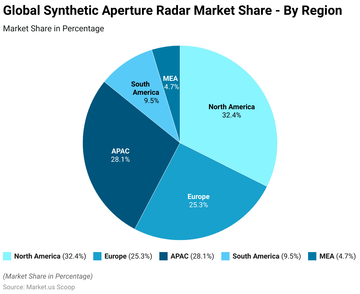
- The global Synthetic Aperture Radar (SAR) market is distributed across various regions, each contributing a significant share. North America holds the largest share at 32.4%.
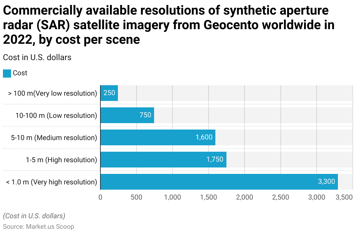
- In 2022, the cost of commercially available Synthetic Aperture Radar (SAR) satellite imagery from Geocento worldwide varied significantly based on the resolution of the images. Very high-resolution images. With resolutions of less than 1.0 meters, were priced at $3,300 per scene.
Synthetic Aperture Radar Market Overview
Global Synthetic Aperture Radar Market Size Statistics
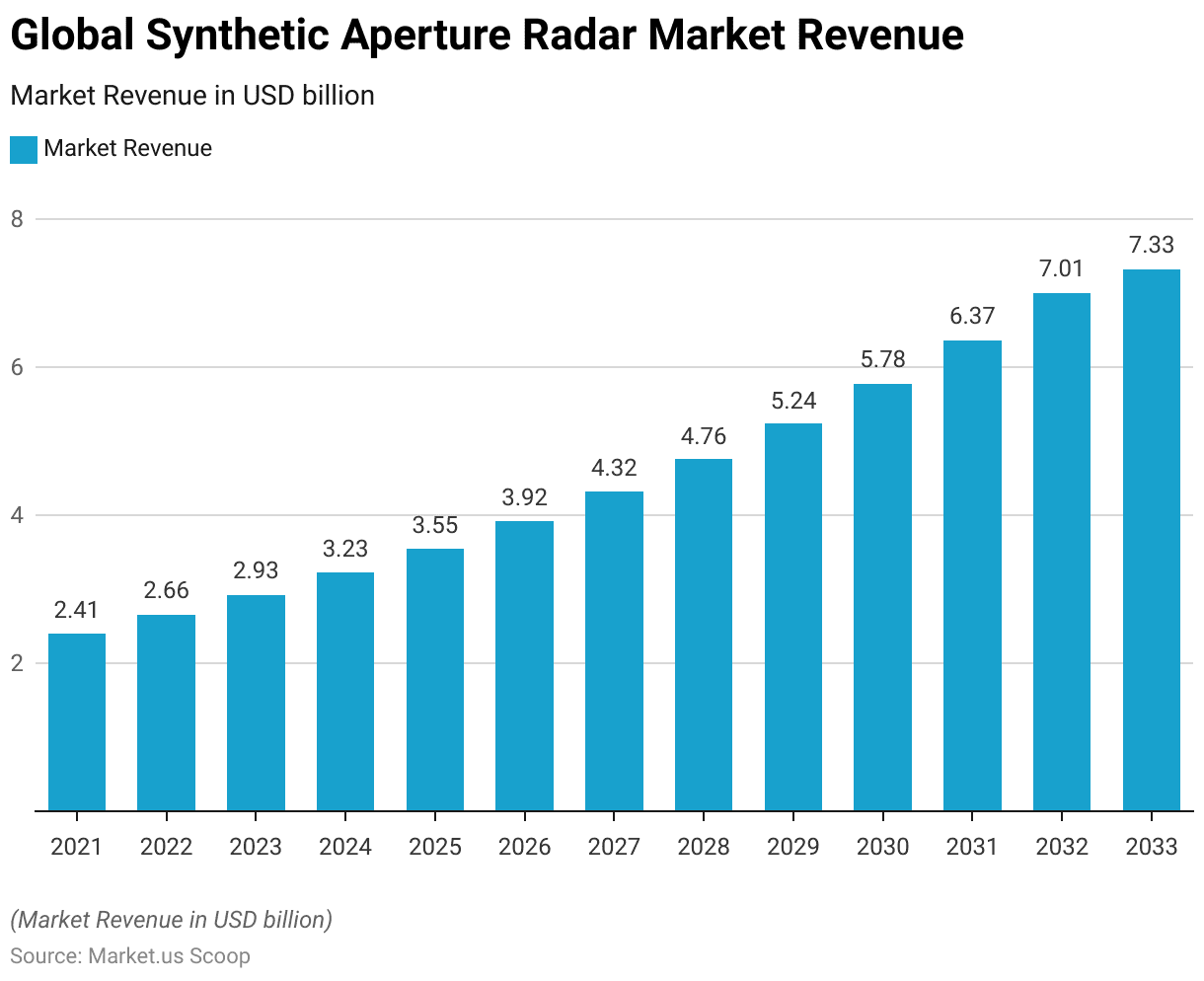
- The global Synthetic Aperture Radar (SAR) market has exhibited a consistent upward trajectory in revenue over recent years at a CAGR of 10.2%.
- In 2021, the market revenue stood at USD 2.41 billion and increased to USD 2.66 billion in 2022.
- This growth trend continued, with revenue reaching USD 2.93 billion in 2023 and further escalating to USD 3.23 billion in 2024.
- The market is projected to maintain this positive momentum. With revenues anticipated to climb to USD 3.55 billion in 2025, USD 3.92 billion in 2026, and USD 4.32 billion in 2027.
- By 2028, the market is expected to achieve USD 4.76 billion. Rising to USD 5.24 billion in 2029 and USD 5.78 billion in 2030.
- Projections for the following years indicate continued growth. The market is reaching USD 6.37 billion in 2031 and USD 7.01 billion in 2032.
- By 2033, the global SAR market revenue is forecasted to attain USD 7.33 billion.
- This sustained growth reflects the increasing demand and advancements in synthetic aperture radar technology across various applications.
(Source: market.us)
Global Synthetic Aperture Radar Market Size – By Frequency Statistics
2021-2027
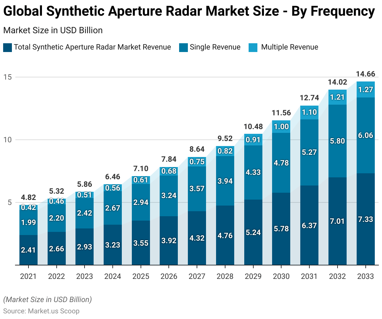
- The global Synthetic Aperture Radar (SAR) market is segmented by frequency. Has shown steady growth in both single and multiple-frequency revenues.
- In 2021, the total market revenue was USD 2.41 billion. Single-frequency revenue contributed USD 1.99 billion, and multiple-frequency revenue accounted for USD 0.42 billion. By 2022, total revenue increased to USD 2.66 billion. With single and multiple-frequency revenues rising to USD 2.20 billion and USD 0.46 billion, respectively.
- However, the upward trend continued in 2023, with the market reaching USD 2.93 billion in total revenue. Comprising USD 2.42 billion from single-frequency and USD 0.51 billion from multiple frequency sources.
- In 2024, the market is projected to grow to USD 3.23 billion, with USD 2.67 billion from single frequency and USD 0.56 billion from multiple frequency. This growth is expected to persist, with 2025 figures reaching USD 3.55 billion overall, USD 2.94 billion from single frequency, and USD 0.61 billion from multiple frequency.
- Moreover, by 2026, the market is forecasted to reach USD 3.92 billion. Including USD 3.24 billion from single frequency and USD 0.68 billion from multiple frequency. The market is projected to achieve USD 4.32 billion in 2027. With single frequency contributing USD 3.57 billion and multiple frequency contributing USD 0.75 billion.
2028-2033
- In 2028, the total market is expected to reach USD 4.76 billion. With USD 3.94 billion from single frequency and USD 0.82 billion from multiple frequency.
- The trend continues in 2029 with a total revenue of USD 5.24 billion. Split into USD 4.33 billion from single frequency and USD 0.91 billion from multiple frequency.
- By 2030, the market is projected to reach USD 5.78 billion in total. With USD 4.78 billion from single frequency and USD 1.00 billion from multiple frequency. In 2031, the market is anticipated to grow to USD 6.37 billion. With a single frequency accounting for USD 5.27 billion and multiple frequencies for USD 1.10 billion.
- The upward trajectory is expected to continue, with 2032 figures reaching USD 7.01 billion in total revenue. Including USD 5.80 billion from single frequency and USD 1.21 billion from multiple frequency.
- By 2033, the global SAR market is forecasted to achieve USD 7.33 billion in total revenue. With single frequency contributing USD 6.06 billion and multiple frequency USD 1.27 billion. This sustained growth reflects the increasing adoption and technological advancements in SAR across various applications.
(Source: market.us)
Global Synthetic Aperture Radar Market Share – By-Mode Statistics
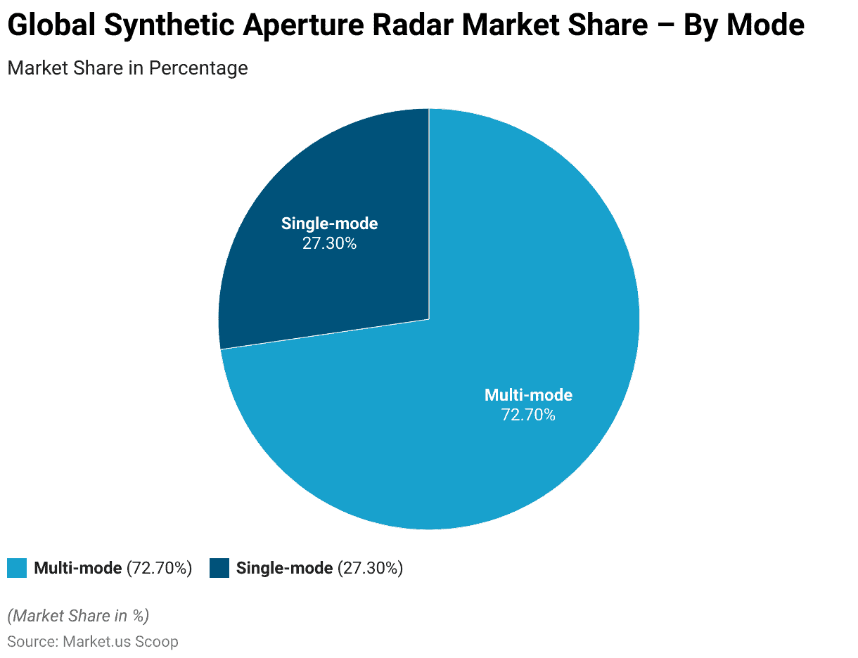
- The global Synthetic Aperture Radar (SAR) market is predominantly driven by multi-mode systems, which command a 72.70% market share.
- In contrast, single-mode systems account for 27.30% of the market.
- This significant preference for multi-mode SAR systems highlights the industry’s focus on versatile and adaptable technologies that can perform a variety of functions and applications. Thereby catering to the diverse needs of end-users across different sectors.
(Source: market.us)
Global Synthetic Aperture Radar Market Share – By Application Statistics
- The global Synthetic Aperture Radar (SAR) market is primarily divided between two major applications: commercial and defense.
- The defense sector holds a slight majority with a market share of 53.70%. Underscoring the critical role of SAR technology in military and defense operations.
- Meanwhile, the commercial sector represents 46.30% of the market. Reflecting the growing utilization of SAR in various commercial applications such as environmental monitoring, infrastructure management, and disaster response.
- This distribution highlights the balanced yet slightly defense-oriented demand within the SAR market.
Competitive Landscape of Global Synthetic Aperture Radar Market Statistics
- Several key players characterize the global Synthetic Aperture Radar (SAR) market, each holding significant market shares.
- Israel Aerospace Industries (IAI) leads the market with a share of 15%. Followed by Airbus SAS with 12% and Northrop Grumman Corporation with 11%.
- Raytheon Technologies Corporation and Capella Space each hold 9% and 10% of the market, respectively.
- Leonardo S.p.A and MDA Corporation each command an 8% market share.
- The remaining 27% of the market is distributed among other key players.
- This competitive landscape highlights the diverse range of companies contributing to the advancements and growth within the SAR industry.
(Source: market.us)
Regional Analysis of the Global Synthetic Aperture Radar Market Statistics
- The global Synthetic Aperture Radar (SAR) market is distributed across various regions, each contributing a significant share.
- North America holds the largest share at 32.4%, reflecting its strong presence in the SAR industry.
- The Asia-Pacific (APAC) region follows with 28.1%, indicating rapid growth and increasing adoption of SAR technology.
- Europe accounts for 25.3% of the market, showcasing its substantial role in the sector.
- South America and the Middle East & Africa (MEA) have smaller shares, with 9.5% and 4.7% respectively.
- This regional distribution underscores the global reach and diverse contributions to the SAR market’s expansion.
(Source: market.us)
History of Synthetic Aperture Radar Technology
- Synthetic Aperture Radar (SAR) technology, conceptualized in 1951 by Carl A. Wiley at Goodyear Aircraft Co., marked a significant innovation in radar systems by utilizing the Doppler effect to generate high-resolution images.
- Initial developments in the 1950s focused on military applications, driven by the need for all-weather, day-and-night reconnaissance capabilities.
- By 1957, the University of Michigan’s Project Wolverine successfully demonstrated airborne SAR. Achieving noteworthy advancements despite the analog processing limitations of the time.
- The 1978 launch of Seasat by NASA represented a pivotal moment. Introducing the first civilian spaceborne SAR and pioneering digital image processing techniques. This milestone catalyzed widespread civilian applications, ranging from environmental monitoring to disaster management.
- Over subsequent decades, continuous improvements in digital processing and satellite technology have firmly established SAR as a critical tool for high-resolution remote sensing across diverse sectors, including geology, oceanography, and forestry.
(Source: ETHW)
Components of Synthetic Aperture Radars
- Synthetic Aperture Radar (SAR) systems are composed of several critical components that enable their high-resolution imaging capabilities.
- The primary components include the radar antenna, which is responsible for transmitting and receiving electromagnetic signals. These antennas can vary in size, with larger antennas providing higher-resolution images.
- The transmitter generates the radar pulses, typically using frequencies in the microwave range. Such as X-band (8-12 GHz), C-band (4-8 GHz), and L-band (1-2 GHz). The receiver captures the reflected signals from the target, which are then processed to construct images.
- Signal processing units are essential for managing the phase history and combining multiple radar echoes to form a synthetic aperture. Thus enhancing resolution beyond the limitations of physical antenna size.
- Other vital components include the data storage and processing systems, which handle large volumes of data and apply algorithms for image reconstruction and analysis.
- Additionally, SAR systems often include motion compensation mechanisms to account for platform movement, ensuring precise aerial imaging.
- These sophisticated components work together to enable SAR’s applications in environmental monitoring, earth observation, and military surveillance.
(Source: NISAR, Springer Link, NASA)
Specifications of Synthetic Aperture Radar Technology Statistics
- Synthetic Aperture Radar (SAR) is a sophisticated imaging technology that leverages the motion of a radar antenna over a target area to create high-resolution images.
- Key specifications of SAR include its velocity and aperture. For instance, NASA’s NISAR mission will utilize an L-band radar with a wavelength of 24 cm and an S-band radar with a wavelength of 10 cm.
- SAR systems, such as the Phased Array Type L-band Synthetic Aperture Radar (PALSAR). It can operate at altitudes around 600-700 km with inclinations near 98 degrees.
- These systems transmit microwave signals, which can penetrate clouds and rain, ensuring functionality in various weather conditions. SAR’s resolution is dictated by factors such as antenna diameter and transmitted pulse width. Achieving resolutions as fine as 5-7 meters along the track.
- SAR also uses polarization techniques to enhance image quality. With pixel brightness influenced by the transmitted energy and surface properties.
- Additionally, SAR’s ability to measure phase shifts allows for the detection of minute surface changes. Making it invaluable for applications ranging from environmental monitoring to military surveillance.
(Sources: ARSET, Capella Space, NISAR, EARTH-DATA)
Synthetic Aperture Radar Band Designations and Applications
- Synthetic Aperture Radar (SAR) technology employs various frequency bands, each with distinct wavelength characteristics and specialized applications. These bands include X, C, L, and P, among others, with frequencies and wavelengths tailored to specific monitoring and observational needs.
- The Ka-band, with frequencies ranging from 27 to 40 GHz and wavelengths of 1.1 to 0.8 cm, is rarely used for SAR but finds applications in airport surveillance.
- The K band (18–27 GHz, 1.7–1.1 cm) is similarly infrequent due to water absorption issues. The Ku band (12–18 GHz, 2.4–1.7 cm) sees limited use in satellite altimetry.
- The X band, operating between 8 and 12 GHz with wavelengths of 3.8–2.4 cm, excels in high-resolution SAR applications such as urban monitoring and ice and snow observation, though it penetrates vegetation poorly.
- The C band (4–8 GHz, 7.5–3.8 cm) is a versatile workhorse for global mapping and change detection, with moderate penetration capabilities and high coherence.
- Moreover, The S-band (2–4 GHz, 15–7.5 cm) is increasingly used for Earth observation. Particularly in agriculture, due to its enhanced vegetation penetration.
- The L band (1–2 GHz, 30–15 cm) provides medium resolution for geophysical monitoring and biomass mapping, offering high penetration and effective Interferometric SAR (InSAR) capabilities.
- Lastly, the P band (0.3–1 GHz, 100–30 cm), still experimental and first deployed in space around 2020, is optimal for biomass and vegetation assessment due to its substantial penetration depth.
- Lastly, These diverse bands enable SAR to adapt to various environmental and observational challenges, enhancing its utility in scientific research and practical applications.
(Source: NASA: EARTH-DATA)
Cost of Synthetic Aperture Radar (SAR) Satellite Imagery
- In 2022, the cost of commercially available Synthetic Aperture Radar (SAR) satellite imagery from Geocento worldwide varied significantly based on the resolution of the images.
- Very high-resolution images, with resolutions of less than 1.0 meters, were priced at $3,300 per scene.
- High-resolution images, with resolutions ranging from 1 to 5 meters, cost $1,750 per scene.
- Medium-resolution images, with resolutions between 5 and 10 meters, were available for $1,600 per scene.
- Low-resolution images, with resolutions from 10 to 100 meters, were priced at $750 per scene.
- Finally, very low-resolution images, with resolutions greater than 100 meters, were the most affordable at $250 per scene.
- This pricing structure reflects the varying levels of detail and potential applications of SAR imagery across different resolutions.
(Source: Statista)
Various Synthetic Aperture Radar Programs and Initiatives
- Leading organizations have developed Various Synthetic Aperture Radar (SAR) programs and initiatives to leverage the technology for diverse applications.
- NASA’s NISAR mission, in collaboration with ISRO, features L-band and S-band SAR instruments aimed at monitoring agricultural conditions forest biomass, and measuring ice sheet dynamics and natural hazards.
- The European Space Agency (ESA) operates the Sentinel-1 constellation, which utilizes C-band SAR for environmental monitoring, maritime surveillance, and disaster response.
- Canada’s RADARSAT program, managed by the Canadian Space Agency (CSA), employs multi-mode C-band SAR for wide-area monitoring of sea ice, surveillance of the marine environment, and disaster management.
- Additionally, the GeoSAR program, a joint initiative by NASA and commercial entities like Fugro EarthData, utilizes P-band and X-band SAR for topographical mapping and forestry applications.
- These programs highlight the global commitment to advancing SAR technology for environmental monitoring, resource management, and disaster response, showcasing the versatility and critical importance of SAR in modern remote sensing efforts.
(Sources: MDPI, eO Portal, ARSET, Applied Sciences – NASA Earth Science Division, EARTH-DATA)
Regulations for Synthetic Aperture Radar
- The regulatory landscape for Synthetic Aperture Radar (SAR) systems is intricate, with varying standards across different countries, reflecting both national security concerns and commercial interests.
- In the United States, the National Oceanic and Atmospheric Administration (NOAA) recently lifted numerous restrictions on commercial remote sensing licenses, enabling higher-resolution SAR imagery, which benefits companies like Umbra. This move aims to bolster US competitiveness in the global market.
- The National Reconnaissance Office (NRO) is also formalizing programs to procure commercial SAR data, emphasizing long-term cost efficiency and operational capabilities.
- In Europe, regulations are more harmonized across member states due to the European Space Agency’s (ESA) oversight, promoting the integration of SAR capabilities for both commercial and defense applications.
- In Asia, China and India are significant players; China’s Gaofen-7 satellite and the NASA-ISRO SAR (NISAR) project underscore a strategic push towards advanced earth observation capabilities.
- Each regulatory framework underscores the balance between leveraging SAR for commercial growth and safeguarding national security interests.
(Sources: Space News, Breaking Defense)
Recent Developments
Acquisitions and Mergers:
- Maxar Technologies acquires Vricon: In mid-2023, Maxar Technologies acquired Vricon, a company specializing in 3D data and geospatial information, for $140 million. This acquisition aims to enhance Maxar’s SAR capabilities by integrating Vricon’s 3D technology, providing more detailed and accurate Earth observation data.
- ICEYE merges with Kongsberg Satellite Services (KSAT): ICEYE, a leader in microsatellite SAR technology, merged with KSAT in late 2023. This merger is expected to improve data delivery and expand the market reach for both companies, enhancing SAR services for environmental monitoring and disaster response.
New Product Launches:
- Capella Space’s Whitney Constellation: In early 2024, Capella Space launched the Whitney Constellation. A network of SAR satellites designed to provide high-resolution imagery and frequent revisit times. This constellation aims to deliver near-real-time data for applications in agriculture, infrastructure monitoring, and national security.
- Sentinel-1C: The European Space Agency (ESA) introduced the Sentinel-1C satellite in late 2023 as part of the Copernicus program. This satellite enhances the Sentinel-1 mission with improved SAR imaging capabilities. Supporting applications in environmental monitoring, maritime surveillance, and emergency response.
Funding:
- ICEYE raises $87 million: In 2023, ICEYE secured $87 million in a Series C funding round to expand its SAR satellite constellation and enhance its data analytics capabilities. Focusing on delivering more comprehensive and timely Earth observation data.
- Capella Space secures $97 million: Capella Space raised $97 million in early 2024 to scale its SAR satellite constellation and invest in advanced data processing technologies. Aiming to provide more accurate and actionable insights.
Technological Advancements:
- AI and Machine Learning Integration: Advances in AI and machine learning are being integrated into SAR data processing to improve image analysis. Automate feature extraction, and enhance anomaly detection, leading to more efficient and accurate data interpretation.
- Miniaturization of SAR Technology: Researchers are developing miniaturized SAR systems that can be deployed on smaller satellites and drones. Making SAR technology more accessible and cost-effective for various applications.
Market Dynamics:
- Growth in SAR Market: The global synthetic aperture radar market is projected to grow at a CAGR of 12.5% from 2023 to 2028. Driven by increasing demand for high-resolution imaging, disaster management, and environmental monitoring.
- Increased Adoption in Agriculture: SAR technology is seeing increased adoption in agriculture for precision farming, crop monitoring, and soil moisture analysis. Helping farmers optimize yields and reduce environmental impact.
Regulatory and Strategic Developments:
- US National Plan for Civil Earth Observations: The US government released the National Plan for Civil Earth Observations in early 2024. Emphasizing the importance of SAR technology for disaster response, climate monitoring, and national security. Encouraging investment and innovation in the sector.
- EU Space Policy: The European Union’s space policy, updated in 2023, supports the development and deployment of SAR satellites as part of its Copernicus program. Aiming to enhance Earth observation capabilities for environmental protection and resource management.
Research and Development:
- Polarimetric SAR (PolSAR): R&D efforts are focusing on the development of Polarimetric SAR technology. Which provides more detailed information about surface properties and targets, enhancing applications in geology, forestry, and urban mapping.
- Interferometric SAR (InSAR): Researchers are advancing Interferometric SAR techniques to measure ground deformation with high precision. Supporting applications in earthquake monitoring, infrastructure stability, and land subsidence analysis.
Conclusion
Synthetic Aperture Radar Statistics – Synthetic Aperture Radar (SAR) has emerged as a vital technology in remote sensing. Offering high-resolution imagery under any weather conditions and at any time of day.
Moreover, Its advancements have enhanced resolution, speed, and the ability to deploy on compact platforms like drones and satellites.
SAR’s applications span topographic mapping, agricultural monitoring, urban planning, and thus disaster response, proving its operational versatility and impact. However, challenges such as high computational demands and complex data interpretation remain.
Finally, Ongoing research aims to address these issues and integrate SAR with other sensor modalities. Ensuring its continued growth and significance in various fields.
FAQs
Synthetic Aperture Radar (SAR) is a form of radar used to create detailed images of landscapes and objects. It operates by sending out radar waves and analyzing the returning signals to construct high-resolution images.
Unlike traditional radar, which provides limited resolution, SAR uses the movement of the radar antenna over a target region to simulate a large antenna or aperture, thus achieving finer-resolution images.
SAR is widely used in various fields, including military and defense, for reconnaissance and surveillance, environmental monitoring, disaster management, thus infrastructure monitoring, and mapping.
In the defense sector, SAR is crucial for its ability to perform reconnaissance and surveillance in all weather conditions, day or night, providing high-resolution images essential for strategic planning and operations.
Commercially, SAR is utilized for environmental monitoring, such as tracking deforestation and ice movements, disaster response like earthquake damage assessment, and infrastructure monitoring, including pipeline surveillance and urban planning.


