Table of Contents
Introduction
According to Aerial Imaging Statistics, Aerial imaging, a method of capturing photographs or videos from airborne platforms—ranging from aircraft and drones to satellites—provides unique, comprehensive views crucial for diverse applications such as agriculture, urban planning, and disaster management.
Utilizing high-resolution cameras and advanced sensors, it offers detailed analyses of large areas impossible to achieve from ground level.
While it presents numerous advantages like extensive coverage and flexibility in use, challenges, including regulatory restrictions, privacy concerns, and weather dependency, also persist.
With its growing importance across various sectors, aerial imaging continues to evolve, promising enhanced data accuracy and broader application possibilities in the future.
Editor’s Choice
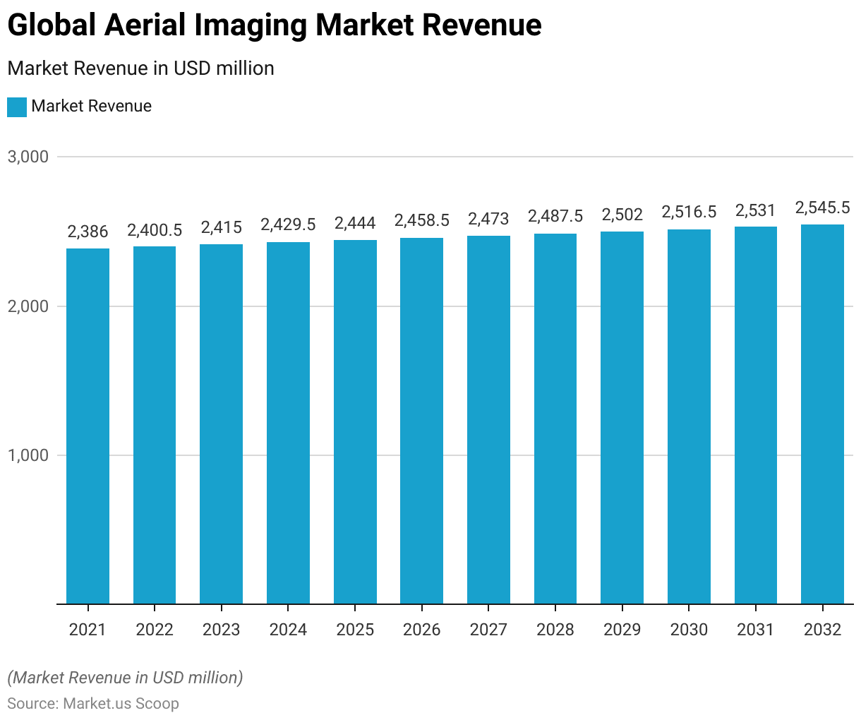
- The global aerial imaging market revenue is projected to reach USD 2,545.5 million by 2032.
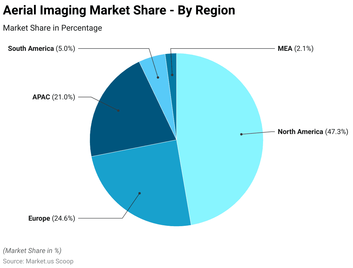
- In terms of market share distribution, North America dominates the global aerial imaging market with a commanding share of 47.3%, followed by Europe at 24.6%.
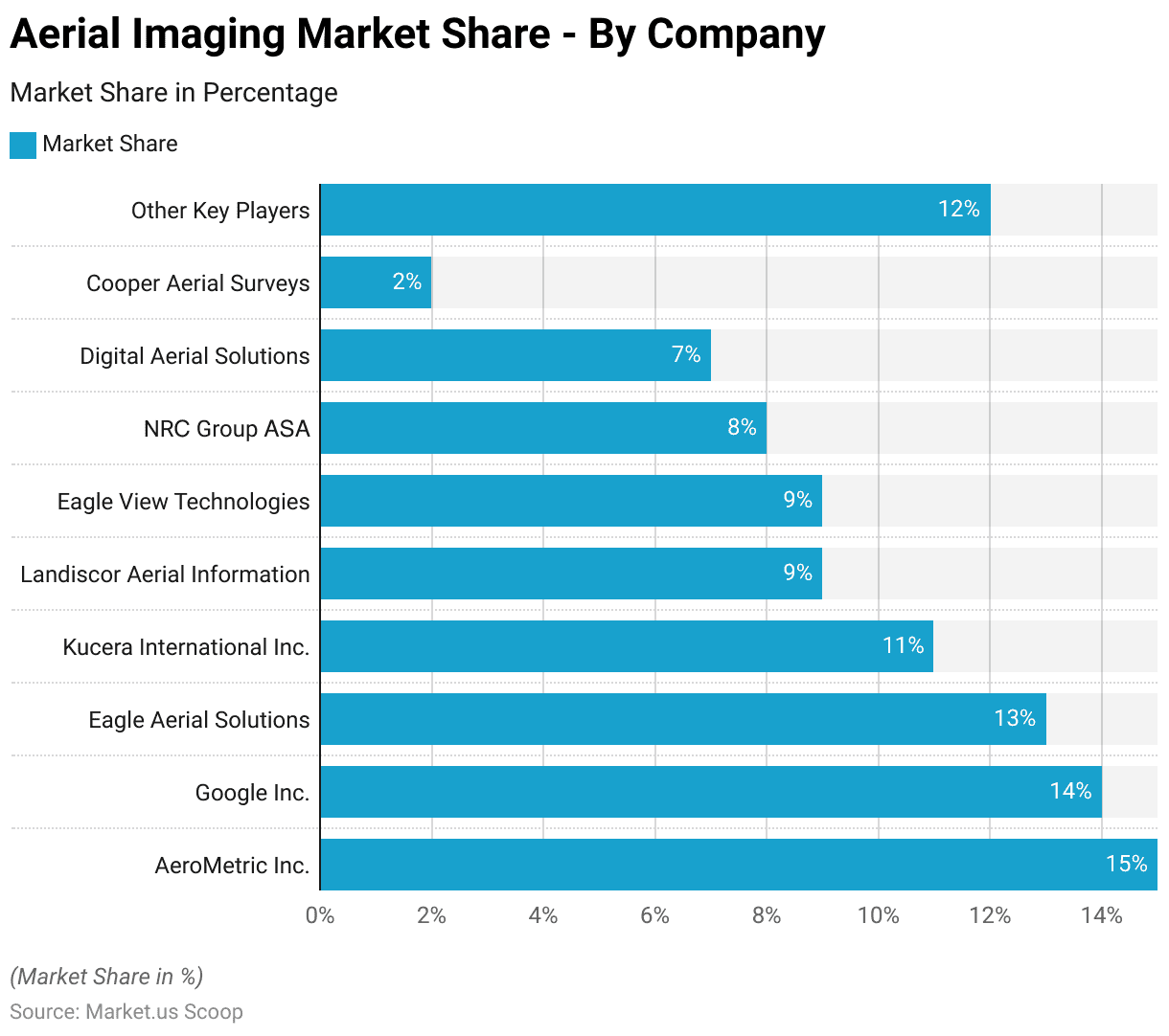
- Among companies, AeroMetric Inc. holds the largest market share at 15%.
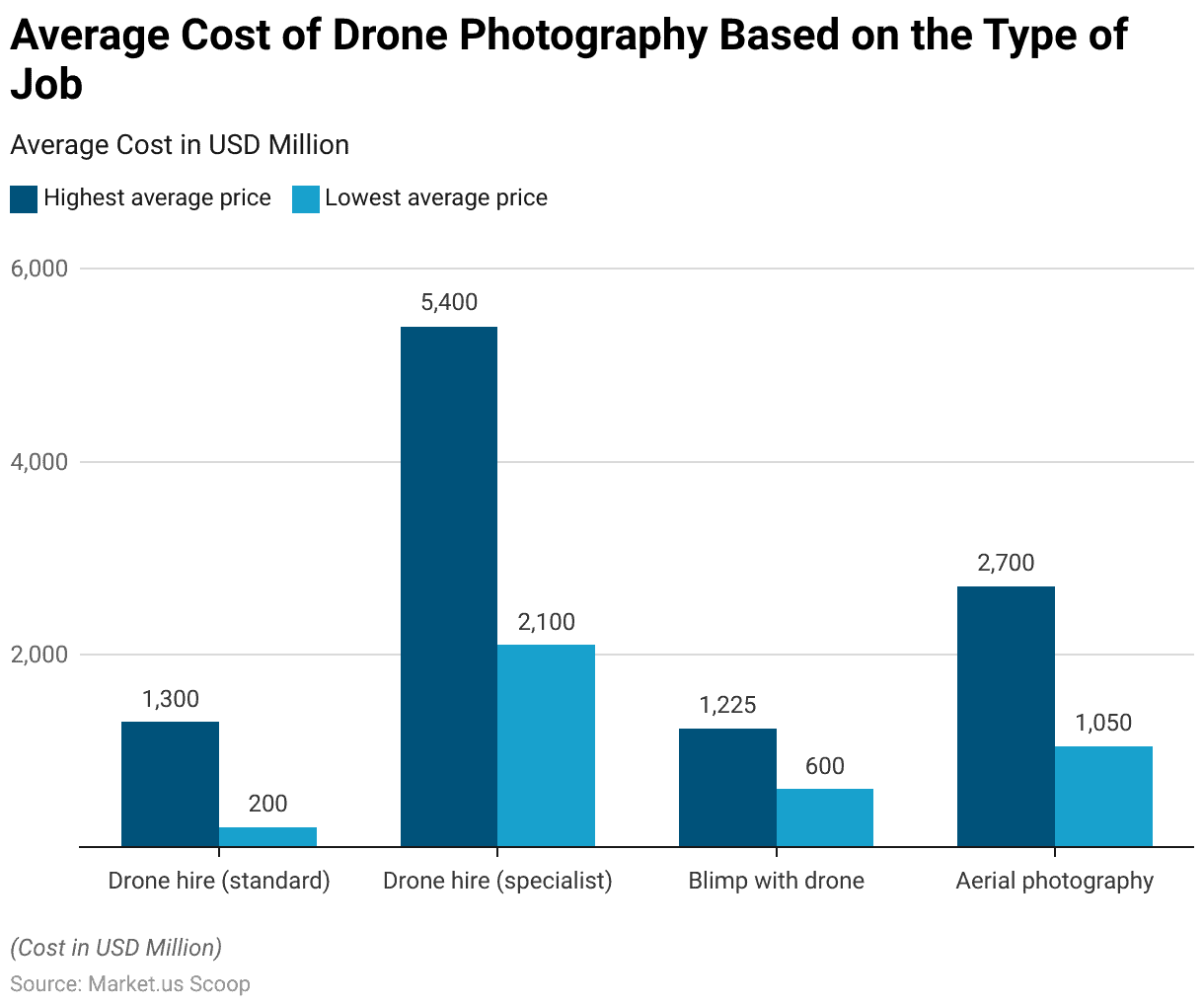
- For standard drone hire, clients can expect rates to fall between $200 and $1,300.
- Neurotechnology, in collaboration with SmartField, has launched DroneScope, an innovative solution merging computer vision and drone technologies for agriculture.
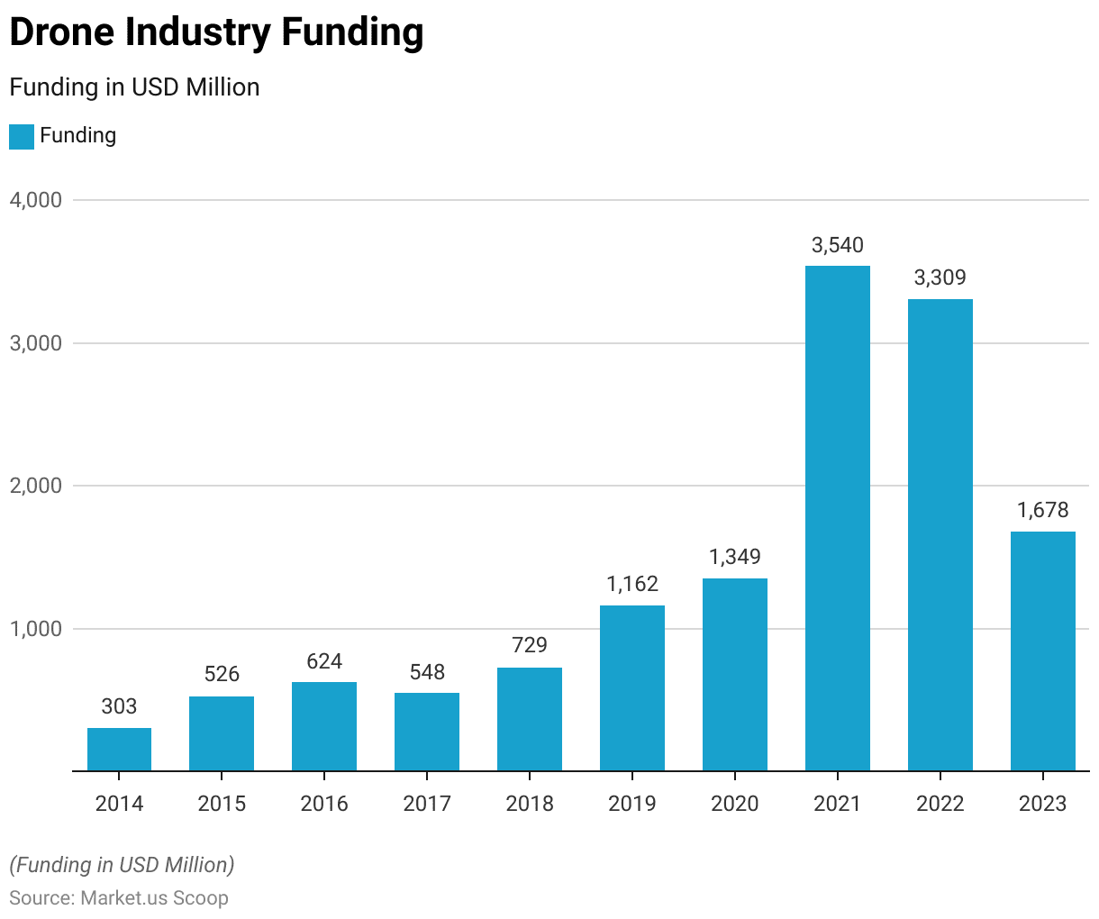
- The drone market funding was valued at USD 1,678 million in 2023.
- By 2029, the U.S. military plans to allocate $2.7 billion toward drone research and development and $3.3 billion towards procurement. These figures may escalate further, considering potential additional funding earmarked for classified projects.
Global Aerial Imaging Market Overview
Global Aerial Imaging Market Size
- The global aerial imaging market has exhibited a gradual increase in revenue from 2021 to 2032 at a CAGR of 14.5%.
- Starting with a revenue of USD 2,386.0 million in 2021, the market saw a modest rise to USD 2,400.5 million in 2022.
- This upward trend continued steadily through the years, with revenue reaching USD 2,415.0 million in 2023 and slightly rising to USD 2,429.5 million in 2024.
- The market is expected to continue its steady growth, with projections of USD 2,531.0 million in 2031 and USD 2,545.5 million by 2032, reflecting a consistent and stable expansion over the decade.
Regional Analysis of the Global Aerial Imaging Market
- In terms of market share distribution, North America dominates the global aerial imaging market with a commanding share of 47.3%, followed by Europe at 24.6%.
- The Asia-Pacific (APAC) region holds a significant portion of the market as well, accounting for 21.0% of the total market share.
- Meanwhile, South America and the Middle East & Africa (MEA) regions have relatively smaller shares, with 5.0% and 2.1% respectively.
Competitive Analysis of the Global Aerial Imaging Market
- The aerial imaging market is characterized by a diverse range of key players, each contributing to the industry’s landscape with varying market shares.
- Among these companies, AeroMetric Inc. holds the largest market share at 15%, closely followed by Google Inc. with 14% and Eagle Aerial Solutions at 13%.
- Kucera International Inc. and Landiscor Aerial Information hold significant shares as well, accounting for 11% and 9%, respectively.
- Eagle View Technologies and NRC Group ASA each secure 9% and 8% of the market, while Digital Aerial Solutions holds a 7% share.
- Cooper Aerial Surveys maintains a smaller presence with 2% of the market.
- Additionally, other key players collectively contribute 12% to the market share.
Cost of Aerial & Drone Photography
Average Cost of Drone Photography
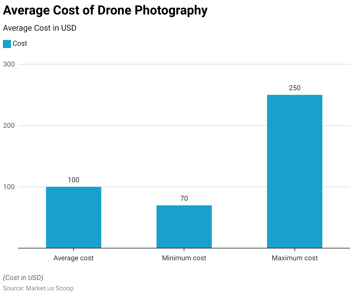
- In the realm of drone photography services, costs vary based on several factors.
- On average, clients can expect to pay around $100 per hour for drone photography sessions. This figure serves as a benchmark against which both minimum and maximum costs can be evaluated.
- At the lower end of the spectrum, some providers offer their services for as little as $70 per hour, providing a cost-effective option for budget-conscious clients.
- Conversely, at the higher end, premium services command rates of up to $250 per hour, reflecting additional value propositions such as advanced equipment, expertise, or specialized techniques.
Cost of Drone Photography Based On the Type of Job
- The average cost of drone photography varies significantly depending on the type of job required, with prices ranging across different categories.
- For standard drone hire, clients can expect rates to fall between $200 and $1,300, with specialist drone hire commanding higher prices averaging between $2,100 and $5,400.
- Utilizing a blimp alongside a drone for aerial photography purposes typically incurs costs ranging from $600 to $1,225.
- Meanwhile, standalone aerial photography services without additional equipment generally range from $1,050 to $2,700.
Average Cost of Drone Photography Based On the Drone Model
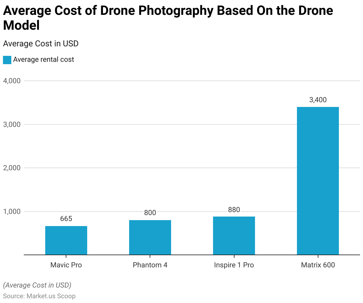
- The average cost of drone photography rental varies depending on the specific drone model chosen for the job. For instance, renting a Mavic Pro typically costs around $665, while opting for a Phantom 4 involves an average rental fee of $800.
- Choosing the more advanced Inspire 1 Pro for aerial photography purposes comes with a slightly higher average rental cost of $880.
- However, for more specialized and professional-grade drone models like the Matrix 600, clients can expect significantly higher rental prices, averaging around $3,400.
Current Technologies in Aerial Imaging
DroneScope Service and Solution
- Neurotechnology, in collaboration with SmartField, has launched DroneScope, an innovative solution merging computer vision and drone technologies for agriculture.
- DroneScope addresses this by utilizing RGB images from standard commercial drones under 900 grams, equipped with 12-megapixel cameras and efficient object avoidance systems.
- This adaptability suits both small and large-scale agricultural needs.
- Its aerial imagery recognition algorithm allows farmers to swiftly and closely monitor crops, surpassing satellite imagery in immediacy and boasting 100 times better survey capacity than humans.
AIR PIX Aerial Camera
- A leading figure in the aerial imaging sector, AirSelfie, unveiled the AIR PIX aerial camera during the Consumer Technology Association (CES) 2020 event.
- Recently, the company has commenced the distribution of AIR PIX+, touted as the world’s smallest pocket-sized aerial camera, to customers worldwide.
- Additionally, AirSelfie has announced plans to release AIR DUO, featuring dual parallel cameras, later in 2020.
Skydio X2
- In July 2020, Skydio, a well-known U.S. drone manufacturer recognized for its proficiency in autonomous flight technology, revealed its latest product: The Skydio X2, designed specifically for enterprise and public sector uses.
- These solutions encompass Skydio Autonomy Enterprise Foundation, Skydio 3D Scan, and Skydio House Scan.
- These software innovations, compatible with the Skydio 2 model as well, play a vital role in the company’s strategy for rapidly advancing its product lineup in the enterprise and government sectors.
- This announcement coincided with Skydio’s successful completion of a $100 million Series C funding round.
DJI’s P4 Multispectral drone
- DJI’s P4 Multispectral drone transforms farming by consolidating data from six sensors to evaluate crop health thoroughly. It assesses crops, including individual plants and entire fields, while also detecting weeds, insects, and diverse soil conditions.
- Equipped with a stabilized imaging system containing an RGB camera and a multispectral camera array with five narrow-band sensors, it captures both visible and invisible light. This data offers professionals vital insights into vegetation stress, soil composition, water salinity, and contamination.
- With built-in communication APIs, DJI SkyPort compatibility, and a gimbal debugging interface, X-Port speeds up sensor innovation development, potentially reducing development time by 40%.
Telefónica Project
- In an initiative led by Telefónica and Correos, a pilot program was introduced in early 2023 in Spain, showcasing the first application of drone package delivery utilizing air traffic control of drones connected to 5G technology.
- This pilot involves the coordinated flight of multiple drones, communicating not only with each other but also with various urban infrastructure components.
- Its purpose is to facilitate package delivery to designated destinations, allowing drones to navigate through potential obstacles and restricted areas with the assistance of real-time warnings.
Investments in Drone Technology
Global Drone Industry Funding
- The funding landscape for the drone industry has witnessed substantial growth over the past decade, with investments steadily increasing from 2014 to 2021.
- In 2014, funding stood at 303 million USD, which more than doubled by 2015, reaching 526 million USD.
- The momentum persisted into the new decade, with 2020 and 2021 recording significant spikes, reaching 1,349 million USD and an impressive 3,540 million USD, respectively.
- However, the growth trajectory shifted in 2022 and 2023, witnessing a slight decline to 3,309 million USD and 1,678 million USD, respectively, marking a notable deviation from the previous upward trend.
Investment and Research & Development
- By 2029, the U.S. military plans to allocate $2.7 billion toward drone research and development and $3.3 billion towards procurement. These figures may escalate further, considering potential additional funding earmarked for classified projects.
- The U.S. Army has utilized diverse drone technologies, among them General Atomics’ MQ-20 Avenger (Predator C), renowned for its capacity to reach speeds of up to 400 knots, ascend over 50,000 feet, and endure flight for more than 20 hours.
- The U.S. Department of Defense (DoD) oversees a fleet exceeding 11,000 drones, including the RQ-4 Global Hawk, employed for both domestic training exercises and international missions.


