
Market Overview
New York, NY – August 27, 2026 – The Global Agriculture Satellite Mapping Services Market reached USD 2.35 billion in 2024. Expects revenue to approach USD 10.37 billion by 2034, with a 16.0% annual growth rate during 2025–2034. Consequently, strong growth signals wider demand for timely field intelligence and better farm decisions for growers, suppliers, and public agencies.
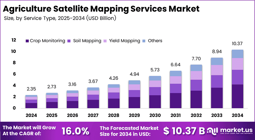
Agriculture satellite mapping services convert Earth observation data into practical maps for growers, advisers, insurers, and public agencies. Moreover, providers combine imagery with weather, soil, and machinery records. These tools help users monitor crop health, define field boundaries, plan irrigation, and estimate yields across broad farming areas with fewer site visits. These capabilities support developed and emerging agricultural markets worldwide.
According to FAO data, agriculture uses more than 70% of global freshwater withdrawals. This share makes irrigation efficiency a major business concern for farms and governments. Therefore, satellite maps can reveal dry zones, crop stress, and uneven growth before operators apply water or other inputs across entire fields. This insight supports water planning and farm resilience.
NASA’s Harmonized Landsat and Sentinel-2 project provides global land observations every 2–3 days at 30-meter resolution. This frequency gives farm teams more current views of vegetation and water conditions. Additionally, regular images support crop monitoring and yield planning, although clouds can still limit optical coverage during critical periods. Service teams can also compare seasonal patterns across multiple growing regions.
USDA counted 1,900,487 American farms across 880 million acres in 2022, while agricultural product sales reached USD 543 billion. These figures show the scale of land and economic activity needing efficient oversight. Consequently, remote monitoring can lower scouting burdens and guide soil mapping, input planning, and crop analysis across diverse operations. Service demand can grow as farms digitize operations.
Key Takeaways
- The market at USD 2.35 billion in 2024 and is forecast to reach USD 10.37 billion by 2034.
- Crop monitoring holds 40.6%, showing that frequent seasonal crop decisions drive service spending.
- Precision farming holds 44.2%, confirming that input savings influence purchasing decisions.
- Optical imaging holds 58.5%, reflecting demand for clear vegetation and crop-color data.
- Agricultural enterprises hold 42.6%, making large farms the main recurring customer base.
- North America holds over 32.8% and generates about USD 0.77 billion, establishing the strongest regional base.
➤ Get Instant Access to the Premium Report Sample Before Purchase – https://market.us/report/agriculture-satellite-mapping-services-market/request-sample/
Market Segmentation
Crop monitoring leads services with a 40.6% share because growers need repeated signals throughout each season. Satellite imagery highlights crop vigor, water stress, pest risk, and uneven growth. Moreover, soil mapping, yield mapping, and other services help teams plan inputs, review results, and manage field records.
Precision farming leads applications with a 44.2% share because mapped zones guide seeding, fertilizer, irrigation, and fieldwork. Operators apply resources where crops should respond best. Therefore, crop scouting, field mapping, and other applications extend the value through targeted visits, boundary management, and operational planning.
Optical imaging holds a 58.5% technology share because visible and near-infrared signals create clear crop maps. Users compare plant cover, leaf condition, crop type, and moisture response. However, radar imaging works through clouds and without daylight, while other technologies add weather or field-level context.
Agricultural enterprises lead end users with a 42.6% share because large operators manage many fields, crops, and suppliers. A common mapping view supports recurring decisions. Additionally, government agencies, research institutions, and other users apply these services to crop estimates, drought response, land records, and food planning.
Regional Analysis
North America led the market in 2024 with more than 32.8% share and about USD 0.77 billion in revenue. This position reflects strong technology use, public support, and established digital farming networks. Moreover, the regional lead gives service providers a large base for subscriptions, analytics, and advisory products.
The United States represented about USD 0.65 billion in 2024 and could reach USD 2.45 billion by 2034 at a 14.2% annual rate. This outlook signals durable demand for crop, soil, and yield intelligence. Meanwhile, Europe and Asia Pacific offer growth through sustainability programs, water needs, and farm digitization.
Market Drivers
Precision farming adoption drives demand because satellite maps turn field observations into repeatable operating choices. The U.S. Government Accountability Office found that only 27% of farms and ranches used precision agriculture during June 2022 through June 2023. Therefore, the adoption gap leaves suppliers substantial room to expand practical services.
Better public satellite data also lowers development barriers for mapping providers. USDA increased Cropland Data Layer resolution from 30 meters to 10 meters beginning in 2024, improving crop and boundary detail. Consequently, vendors can build sharper planning tools, while growers gain clearer information for scouting and resource decisions.
Market Use Cases
Farm managers use satellite crop monitoring to direct scouts toward fields that show unusual plant stress or uneven growth. Moreover, advisers compare recent images with weather and field notes before recommending action. This workflow saves travel time, improves visit priorities, and helps teams respond earlier to emerging crop problems.
Irrigation teams use field maps to locate dry zones and compare moisture patterns across farms. Additionally, operators can adjust watering plans before stress spreads across a crop. The same information helps managers review drainage, schedule equipment, and document field conditions for discussions with agronomists, insurers, or lenders.
Business Opportunities
Carbon and nature verification creates a strong expansion path for satellite mapping providers. Companies can document cover crops, land-use change, biomass, and field practices for environmental programs. Moreover, trusted records can move suppliers beyond seasonal advice into recurring assurance services, provided they use clear methods, independent checks, and farmer consent.
Insurance integration offers another attractive growth route. Providers can combine crop maps, weather records, and field boundaries to support faster risk reviews and claims decisions. Additionally, input suppliers and farm platforms can embed mapping into existing workflows, giving growers easier access while creating broader distribution channels for service companies.
Major Challenges
Cloud cover limits optical images during planting, irrigation, and disease monitoring, especially in tropical and monsoon regions. Providers must combine optical data with radar, weather records, and local observations. However, this mixed approach raises processing costs and requires careful checks before advisers can trust the resulting crop recommendations.
Small farms often struggle with subscription fees, devices, connectivity, and training. Farm data also sits across incompatible machinery and software systems, which slows analysis. Therefore, suppliers must offer simple pricing, mobile access, clear ownership rules, and reliable support while building products that exchange information across common farm platforms.
Top Key Players in the Market
- Trimble Inc.
- John Deere
- Planet Labs Inc.
- Airbus Defence and Space
- BASF SE
- The Climate Corporation, a subsidiary of Bayer AG
- GeoOptics Inc.
- Orbital Insight
- Taranis
- Descartes Labs
- Farmers Edge Inc.
- AgEagle Aerial Systems Inc.
- Earth-i Ltd.
- SatSure Ltd.
- Geosys
- Mavrx Inc.
- PrecisionHawk Inc.
- Ag Leader Technology
- Sentera
- SlantRange Inc.
- Other market participants
Conclusion
Agriculture satellite mapping services are moving from basic imagery toward practical decision support for farms, agencies, insurers, and advisers. Crop monitoring, precision farming, optical data, and enterprise demand shape today’s market. Moreover, water pressure, better satellite access, and digital workflows support expansion. Providers that solve affordability, cloud coverage, data sharing, and trust can build services across regions and farm sizes.
Discuss your needs with our analyst
Please share your requirements with more details so our analyst can check if they can solve your problem(s)